Water Resource Assessment and Optimization for the Hill Watershed of Southern China
by Jeffrey Yen Cheng1, Mao Heng2, Xu Zhu2, Liao MR3
1Room 2002, Advanced Institute of Information Technology, Peking University, 233, Ningwei Street, Xiaoshan District, Hangzhou city, Zhejiang Province, China; Jcheng6078@gmail.com.
2988, Panyou Road, Shushan Street, Xiaoshan District, Hangzhou City, Zhejiang Province, China; senlinmiwu@163.com
2988, Panyou Road, Shushan Street, Xiaoshan District, Hangzhou City, Zhejiang Province, China; 63133249@qq.com
3Room 2002, Advanced Institute of Information Technology, Peking University, 233, Ningwei Street, Xiaoshan District, Hangzhou city, Zhejiang Province, China; meirui.liao@qinkung.com
*Corresponding author: Jeffrey Yen Cheng, Director of AI Hydro Lab, Advanced Institute of Information Technology, Peking University, China
Received Date: 06 September, 2023
Accepted Date: 14 September, 2023
Published Date: 20 September, 2023
Citation: Cheng JYC, Heng M, Zhu X, Liao MR (2023) Water Resource Assessment and Optimization for the Hill Watershed of Southern China. J Earth Environ Sci 6: 198. https://doi.org/10.29011/2577-0640.1001198
Abstract
This study introduces a water resource assessment and optimization system aimed at improving water supply and optimizing irrigation in the hill area of southern China. Focused on addressing drought vulnerability, hill flash flood prediction, and reservoir operation optimization by integrating Geographic Information System (GIS), Building Information Modeling (BIM), hydrology and hydraulic modeling (H&H modeling), and Supervisory Control and Data Acquisition (SCADA) technologies. The system’s structure involves a GIS model for reservoir watershed identification, a BIM model for essential reservoir data integration, and hydraulic modeling for flow simulation and storage optimization. Real-time data from strategically positioned SCADA sensors contribute to a continuous simulation database, enabling real-time monitoring of flow and depth, along with spatial and temporal rainfall forecasts. During drought events, the system transforms into a decision-support tool.
The developed system was implemented in a southern Chinese village spanning 15 km² of irrigated land with eight years of continuous precipitation records. The watershed has 22 on-stream reservoirs with varied storage volumes and irrigation demands. The project follows three phases: data collection and assessment, GIS and BIM model creation for daily operational analysis, and SCADA installation for engineering analysis. The third phase integrates a hydraulic model to predict, simulate, and optimize the irrigation system. Anticipating future progress, Genetic Algorithms and machine learning will be integrated for enhanced optimization and reduced management costs. Overall, this research embodies a comprehensive approach, merging advanced technologies and data-driven methodologies to provide practical solutions for agricultural resilience in the face of water scarcity.
Keywords: GIS; Hydrological and Hydraulic models; Irrigation; SCADA; Water resource database
Problem Statement and Background
The hill irrigation systems that support agriculture in various regions are currently facing complex challenges arising from the intersecting impacts of climate change, heightened agricultural water demand, and the escalating costs associated with maintaining watershed reservoirs. These challenges pose a significant threat to the sustainability and productivity of agricultural practices in these areas. Addressing these multifaceted issues requires a comprehensive understanding of their interdependencies and the development of integrated strategies that can ensure the continued viability of hill irrigation systems.
Climate Change Impact
Climate change has led to erratic rainfall patterns, increased temperature extremes, and altered hydrological cycles in many regions with hill irrigation systems. These changes disrupt traditional irrigation schedules and water availability, leading to difficulties in managing water resources effectively [1]. It is imperative to assess how these changing climatic conditions affect water availability for irrigation, as well as identify strategies to adapt irrigation practices to the new normal. The hydrological problems that we face in hill irrigation are
Changes in precipitation patterns: Climate change is expected to cause changes in precipitation patterns in South China, which could result in more frequent and severe droughts or floods. This could affect the availability of water resources for irrigation and lead to reduced crop yields. Typical rainfall patterns in Southern China are the summer extreme warm-sector rainfall event (MayYu), and the rain cloud with high moisture brings by the typhoon between midMay to late October yearly [2]. Because of the uneven temporal distribution of precipitation due to monsoons, the importance of watershed management in conjunction with year-round irrigation is very high [3]. However, the precipitation patterns change is not fully recognized at the hill watershed. Watershed management and irrigation management are deemed to be separate entities and practiced accordingly at present.
Increase in temperature: Higher temperatures due to climate change could increase the rate of evaporation, leading to increased water loss from irrigation systems. This could reduce the amount of water available for crops, leading to decreased yields. Increased frequency and severity of extreme weather events: Climate change is expected to increase the frequency and severity of extreme weather events, such as typhoons and heavy rainstorms [4]. These events could damage irrigation infrastructure and disrupt water distribution, leading to reduced crop yields. Furthermore, extreme weather events could also lead to soil erosion and nutrient loss, which could affect soil quality and reduce crop yields.
High Agricultural Water Demand: Rapid population growth and increased agricultural production have resulted in heightened demands for water in hill regions. The pressure to produce more food exacerbates the strain on existing water resources, often leading to unsustainable extraction from reservoirs and groundwater sources. Balancing the agricultural water demand with the available supply is crucial to prevent overexploitation and ensure equitable distribution among farmers.
Watershed Reservoir Operation and Maintenance Cost: The maintenance and management of reservoirs play a pivotal role in storing water for irrigation during dry periods. However, the costs associated with reservoir maintenance, including silt removal, dam repairs, and infrastructure upgrades, have been on the rise. These expenses can strain local budgets and hinder the efficient operation of irrigation systems. Finding cost-effective solutions for reservoir maintenance and exploring innovative funding mechanisms are essential to keep these systems functional [2]. The maintenance costs associated with irrigation structures, reservoirs, and drainage channels represent a critical challenge in ensuring the efficient and sustainable management of water resources for agricultural and environmental purposes. As these infrastructure components play a vital role in water distribution, storage, and flood control, addressing the escalating maintenance expenses requires a comprehensive understanding of the underlying issues and the development of effective, long-term solutions.
Maintenance Cost Escalation: The costs of maintaining irrigation structures, reservoirs, and drainage channels have been on the rise due to factors such as aging infrastructure, changing environmental conditions, and increased material and labor expenses. These escalating costs strain the financial resources of managing authorities and communities, potentially leading to deferred maintenance, system failures, and reduced overall efficiency.
Infrastructure Degradation and Inefficiency: Unaddressed maintenance needs can result in the deterioration of irrigation structures, reservoirs, and drainage channels, compromising their effectiveness in water storage, distribution, and flood mitigation. Structural deficiencies, such as leaks, erosion, and sediment buildup, lead to reduced water conveyance capacity and inefficient resource utilization [1]. This can ultimately lead to decreased agricultural productivity, environmental degradation, and increased vulnerability to flooding events.
Balancing Budget Constraints and System Performance: The challenge lies in striking a balance between limited budgets and the imperative to maintain functional and efficient water infrastructure. Decision-makers often face difficult choices regarding resource allocation, choosing between addressing urgent maintenance needs and investing in long-term infrastructure improvements that can enhance system resilience and reduce overall costs.
Methods and Approach
Considering these challenges, a holistic approach is required that considers the interactions between climate change, agricultural water demand, and reservoir maintenance costs. This approach should involve:
- Assessing the vulnerability of hill irrigation systems to changing climatic conditions and identifying suitable adaptation strategies.
- Developing efficient water-use practices and technologies to optimize agricultural productivity while minimizing water consumption.
- Exploring sustainable methods for watershed management and reservoir maintenance that reduce costs and ensure longterm functionality.
Addressing the issues faced by hill irrigation systems will not only safeguard agricultural livelihoods but also contribute to water resource conservation, ecological balance, and the overall resilience of communities in these regions. To monitor the water resource and develop the operation procedure for the hill irrigation, the system needs to combine the GIS integration with BIM of irrigation infrastructure, Hydrology and Hydraulic Models, with IOT that connect SCADA and automation system of hydraulic structure.
GIS
Integrating Geographic Information Systems (GIS) with hydrological model creation involves a systematic approach to gathering, processing, and analyzing spatial data for an accurate representation of hydrological processes. Beginning with data collection, various sources provide topographic, land use, soil, climate, and hydrological network data [5]. Once gathered, GIS software is employed to manage and preprocess the data. Through spatial analyses, the topography’s influence on water flow, land cover’s impact on runoff, soil characteristics affecting water movement and climate data interpolation are assessed. Additionally, the hydrological network is analyzed to understand flow paths and drainage areas. These insights are then incorporated into hydrological modeling tools, with GIS aiding in model calibration and validation. The GIS-enabled model facilitates scenario analyses, helping anticipate the effects of land use changes or climate shifts on water systems. Ultimately, the integration of GIS with hydrological modeling enhances our understanding of water movement, supporting informed decision-making for water resource management and land use planning.
Using GIS for data collection and spatial analysis in the creation of a hydrological model involves several steps to gather relevant spatial data, analyze it, and develop an accurate model of the hydrological processes in each area. Here is a step-by-step guide:
Data Collection: Gather spatial data related to the hydrological system you want to model. This could include topographic data, land use/land cover data, soil data, climate data, and hydrological network data (rivers, streams, etc.). Sources of this data might include government agencies, satellite imagery, aerial photography, and field surveys [6]. Organize and preprocess the collected data to ensure consistency and compatibility. This involves georeferencing, projection matching, and data cleaning to remove inconsistencies or errors.
Topographic Analysis: Utilize elevation data (Digital Elevation Models - DEM) to analyze topography, slope, aspect, and flow direction. These factors influence surface water flow patterns and can be crucial in hydrological modeling.
Land Use/Land Cover Analysis: Analyze land use and land cover patterns using GIS tools. Determine how different land cover types affect runoff, infiltration, and other hydrological processes.
Soil Data Integration: Integrate soil data into your GIS to understand soil characteristics such as permeability, porosity, and infiltration rates. This information helps simulate how water moves through the soil.
Climate Data Incorporation: Include historical and current climate data like precipitation and temperature. Use GIS tools to spatially interpolate weather data, creating continuous surfaces for input into your hydrological model.
Hydrological Network Analysis: Analyze the river and stream network, identifying flow paths, drainage areas, and stream order. This information is vital for simulating water flow and routing.
Spatial Analysis: Utilize GIS spatial analysis tools to calculate variables like watershed delineation, flow accumulation, and flow direction. These analyses help define the boundaries of your hydrological model and how water moves through the landscape.
Model Calibration and Validation: Develop a hydrological model based on the spatial data and analyses performed in GIS. Calibrate the model using observed data and validate it against independent datasets to ensure its accuracy.
Visualization and Reporting: Use GIS to visualize model outputs spatially. Create maps that depict variables such as runoff, groundwater levels, and flow paths. These visualizations aid in understanding and communicating the hydrological processes [7]. Utilize GIS to test different scenarios and assess the potential impact of changes in land use, climate, or other factors on the hydrological system. This helps in decision-making and planning for various scenarios.
Hydrological model: Effective management of water resources in hill watersheds demands a thorough understanding of the intricate hydrological processes that govern water availability, distribution, and utilization. Hydrological models play a pivotal role in this endeavor by providing a comprehensive framework to assess water resources through key aspects such as water budget balance, reservoir water storage, and operational strategies [8]. Hydrological models contribute to assessing water resources within the context of hill watershed management should include the following.
Water Budget Balance Assessment: Understanding the water budget balance is essential in evaluating the availability and utilization of water within a hill watershed. Hydrological models simulate the inflows and outflows of water components, including precipitation, evapotranspiration, surface runoff, groundwater recharge, and losses. By accurately quantifying these processes, the model creates a comprehensive picture of water availability over time [9]. This information is vital for identifying water surplus or deficit periods, understanding the impact of climate variability, and making informed decisions regarding water allocation for various uses.
Reservoir Water Storage Assessment: Reservoirs serve as critical storage components within hill watersheds, contributing to water supply, flood control, and energy generation. Hydrological models facilitate the assessment of reservoir water storage dynamics by considering inflows, outflows, and operational strategies. These models simulate how water accumulates during periods of excess flow and is released during times of demand or controlled discharge. By evaluating reservoir behavior under different scenarios, stakeholders can optimize water storage, anticipate reservoir capacity changes, and develop strategies to manage potential flooding or drought situations.
Reservoir Operation Strategy Evaluation: The operational management of reservoirs involves determining the most efficient release strategies to meet various demands while maintaining storage levels and minimizing conflicts. Hydrological models enable the simulation of different operational scenarios, considering variables such as water supply needs, ecological requirements, energy generation, and flood control [10]. These models help decision-makers assess the trade-offs between different uses and guide the development of operation strategies that align with sustainable watershed management goals.
In practical application, hydrological models are calibrated using historical data and validated against observed conditions to ensure accuracy. Once validated, these models can be used for scenario analysis, allowing stakeholders to assess the impacts of various interventions, such as land use changes or infrastructure development, on water availability, reservoir storage, and operational outcomes. This approach enhances decision-making by providing insights into how different management strategies affect the overall water balance and resource availability.
By integrating hydrological models into hill watershed management, stakeholders gain a deeper understanding of the complex interplay between hydrological processes, reservoir storage dynamics, and operational strategies. This holistic approach empowers decision-makers to develop informed and sustainable water resource management plans that consider the needs of agriculture, communities, ecosystems, and other stakeholders [11] (Figure 1).
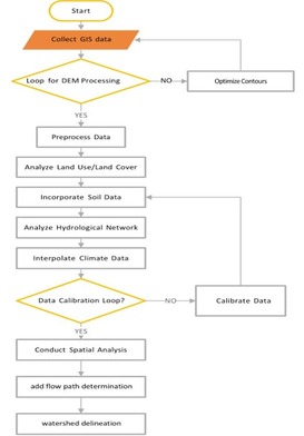
Figure 1: GIS Spatial analysis for the watershed delineation.
Within the confines of a catchment, the interpretation of the hydrologic cycle gives rise to the concept of a hydrologic budget. The hydrologic budget involves accounting for the different transport phases of the hydrologic cycle within a catchment, all with the goal of determining their respective magnitudes [12].
∆S=P-(E+T+F+Q)
In which, ΔS = change in storage, P = precipitation, E = evaporation, T = evapotranspiration, F = infiltration to groundwater, and Q = surface runoff.
Within a given time limit, the change in water depth remaining in storage in a unit area is the difference between precipitation and the sum of soil infiltration, evaporation, evapotranspiration, and ground/surface outflow. From the water depth point of view, consider the change in storage to be the excess rainfall depth, which is Ie= ΔS.
In the hill watershed, small reservoirs are designed for irrigation needs and to diffuse provided the flood mitigation from mountain flash surface runoff. The typical size for these small reservoirs storage volume ranges between 25,000-80,000 cubic meters, and control depth from five to 15 meters high, which is based on the catchment basins water resource and the construction/ operation cost [6]. A typical hill watershed detentions inflow is dependent on the catchment hydrological condition, and outflow is dominated by types: (1) uncontrolled, (2) controlled, or (3) a combination of both. Uncontrolled outflow is not subject to operator intervention, such as an ungated overflow spillway. On the other hand, controlled outflow is subject to operator intervention, as in the case of a gated orifice or spillway. In certain instances, reservoirs are outfitted with a combination of controlled and uncontrolled outflow devices or structures [9]. In a reservoir with controlled outflow, gates are used for the purpose of regulating flow through the outlet structures. The gates are operated following established operational rules. These rules determine the relation between inflow, outflow, and reservoir storage volume, considering the daily, monthly, or seasonal downstream water demands. The latter may include the minimum ecological demanding flow requirement for water quality or fisheries management [13].
At the intersection of advanced technology and natural resource management, a SCADA (Supervisory Control and Data Acquisition) system emerges as a sophisticated amalgamation of hardware and software. Primarily designed to monitor and regulate various industrial processes and infrastructures, the application of SCADA extends notably to the complex realm of hill watershed water resource management. Within this context, a SCADA application assumes a pivotal role, meticulously overseeing the intricate collection, analysis, and control of waterrelated processes. As hill watersheds stand as pivotal regional components of water supplies, characterized by intricate terrains, shifting climatic patterns, and diverse ecosystems, the significance of effective water resource management within these contexts becomes unmistakable. The SCADA application, with its capacity to navigate this intricate landscape, emerges as a linchpin in ensuring a continuous and sustainable supply of clean water to cater to the needs of both humanity and the environment alike.
A SCADA application tailored for hill watershed water resource management brings a multitude of benefits to this intricate ecosystem [14]. By harnessing real-time data collection and analysis, such a system empowers stakeholders with the insights needed for informed decision-making. This leads to the efficient allocation of water resources, minimizing waste and ensuring a sustainable supply for both human and ecological needs. Moreover, the incorporation of alarms and alerts creates early warning systems that enable rapid responses to potential threats like floods or droughts, safeguarding communities and environments alike. The ability to remotely control water-related infrastructure adds an extra layer of flexibility and efficiency, reducing operational costs and the need for physical interventions [15]. Beyond its operational advantages, this technology plays a vital role in protecting the environment by closely monitoring the watershed’s health and supporting ecologically conscious practices.
The required equipment for this project can be mainly categorized into hydrological measurement, water quality measurement, and hydrological observation. Flow meters are primarily used to record the water volume in the selected upstream and downstream areas of the watershed. Automated observation and online recording mechanisms are employed, constituting water flow detection equipment. Amidst the rugged terrain of multiple rivers and valleys, a complex hydrological model has been developed to understand water movement, reservoir management, and watershed delineation. This model considers factors such as topography, rainfall patterns, soil types, and land use. The Da Tong Stream data is monitored using flow meters, with automatic control switches deployed at the reservoir.
Case Studying
Watershed Overview: The hydrological system encompasses the Da Tong Stream, which serves as a tributary merging into the middle reaches of the Lou Ta Stream, and subsequently converging with the Qian Tang River. Encompassing an expanse of 15.0 km2, the watershed encompasses a river span of 8.49 km characterized by an average slope of 14.13%. The Da Tong Village, Da Tong Second Village, and Da Tong Third Village are sequentially traversed by the stream, accommodating a collective populace of approximately 8,000 individuals. As a result of this high population density, both the land adjoining the stream and the stream itself are characterized by a substantial ratio
of impervious surfaces, necessitating the construction of an engineered channel with three distinct sections of channel geometry. The channel’s dimensions span between 6 to 12 meters in width, with depths ranging from 1.5 to 3 meters, inclusive of freeboard provisions.
The region’s undulating terrain, featuring hills, mountains, and plains, exerts a notable influence on both the patterns of rainfall runoff and the convergence of water flow. Noteworthy for its plentiful water resources and diverse vegetation, the watershed provides an accommodating habitat for numerous organisms while simultaneously contributing to the preservation of water resources and the broader ecological environment. Crucially, the Da Tong Stream watershed functions as a pivotal water source for the urban domain of Hangzhou, fulfilling a multifaceted role encompassing irrigation, rural domestic use, and municipal water supply. Within the watershed, 22 small reservoirs are distributed, boasting an average capacity of approximately 20,000 cubic meters. Detailed information regarding the reservoirs’ attributes, including volume and elevational specifications under normal, designed, and flood conditions, is cataloged within the accompanying Table 1.
|
Order Number |
Village Community |
Name |
Storage capacity (normal water level) (1000 m3) |
Storage capacity (designed flood level) (1000 m3) |
Storage capacity (check flood level) (1000 m3) |
Reservoir Level |
||
|
Flood limited. level |
Dead level |
normal water level |
||||||
|
1 |
Datong one village |
Reservoir 1 |
68 |
85.1 |
92.2 |
159 |
152.52 |
157.67 |
|
2 |
Reservoir 2 |
65.5 |
80.1 |
86.2 |
132.14 |
126.27 |
131.42 |
|
|
3 |
Reservoir 3 |
36.3 |
40.7 |
42.4 |
132.66 |
126.55 |
131.70 |
|
|
4 |
Reservoir 4 |
10.6 |
11.8 |
12.4 |
145.15 |
139.43 |
144.58 |
|
|
5 |
Reservoir 5 |
12.6 |
15.4 |
16.7 |
102.46 |
96.78 |
101.93 |
|
|
6 |
Reservoir 6 |
10.2 |
11.4 |
12.0 |
118.56 |
112.92 |
118.07 |
|
|
7 |
Datong two village |
Reservoir 7 |
34.5 |
43.5 |
47.3 |
98.84 |
92.92 |
98.07 |
|
8 |
Reservoir 8 |
16.8 |
18.9 |
19.8 |
91.09 |
85.34 |
90.49 |
|
|
9 |
Reservoir 9 |
27.2 |
30.6 |
32.0 |
124.02 |
118.19 |
123.34 |
|
|
10 |
Reservoir 10 |
24.2 |
29.2 |
31.5 |
138.72 |
132.30 |
137.45 |
|
|
11 |
Reservoir 11 |
13.0 |
15.6 |
16.7 |
111.5 |
100 |
106 |
|
|
12 |
Reservoir 12 |
12.8 |
14.5 |
23.2 |
97.5 |
87 |
91.8 |
|
|
13 |
Reservoir 13 |
10 |
13.0 |
14.3 |
103.17 |
97.05 |
102.20 |
|
|
14 |
Reservoir 14 |
12.3 |
13.6 |
14.2 |
110.01 |
104.35 |
109.50 |
|
|
15 |
Reservoir 15 |
24.5 |
27.8 |
29.3 |
105.76 |
100.05 |
105.20 |
|
|
16 |
Datong three villages |
Reservoir 16 |
52 |
60.2 |
64.1 |
74.43 |
68.61 |
73.76 |
|
17 |
Reservoir 17 |
26.0 |
31.9 |
34.5 |
85.31 |
79.25 |
84.40 |
|
|
18 |
Reservoir 18 |
12.4 |
14.8 |
15.9 |
67.78 |
62.15 |
67.30 |
|
|
19 |
Reservoir 19 |
3.56 |
45.2 |
49.4 |
90.14 |
84.58 |
89.73 |
|
|
20 |
Reservoir 20 |
9.6 |
10.9 |
11.5 |
93.5 |
82 |
88 |
|
|
21 |
Reservoir 21 |
12.3 |
1.39 |
14.6 |
83.5 |
77.81 |
82.96 |
|
|
22 |
Guancun village |
Reservoir 22 |
14.0 |
17.4 |
18.9 |
59.59 |
53.52 |
58.67 |
Table 1: Reservoir list of Studying watershed.
The present study is centered on the investigation of a distinctive watershed characterized by its classification as a mountain stream, characterized by abbreviated length and a notably swift flow rate. This watershed, owing to its inherent attributes, is susceptible to abrupt oscillations and inundations, particularly in response to typhoons and the prevailing “Mai-Yu” precipitation pattern. The encompassing topography, characterized by steep slopes, in conjunction with constrained reservoir capacity, necessitates the reliance on mountain ponds and reservoirs to fulfill water storage requisites [6]. Considering these complexities, the integration of the proposed model assumes paramount importance. This integration facilitates a comprehensive assessment of water resources, thereby facilitating the computation of the optimal water storage depths germane to the contiguous mountain ponds. This judicious approach serves a dual purpose: firstly, to curtail the vulnerability to flash floods precipitated by intense rainfall events; secondly, to preemptively address concerns pertaining to potential water scarcity scenarios. Through this model-driven methodology, a proactive and adaptive water management strategy can be fostered, affording resilience in the face of hydrological uncertainties (Figures 2-4).
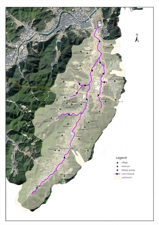
Figure 2: Distribution diagram of river network and reservoirs.
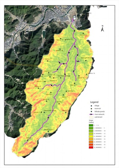
Figure 3: Elevation and Slope Map of the studying Watershed.
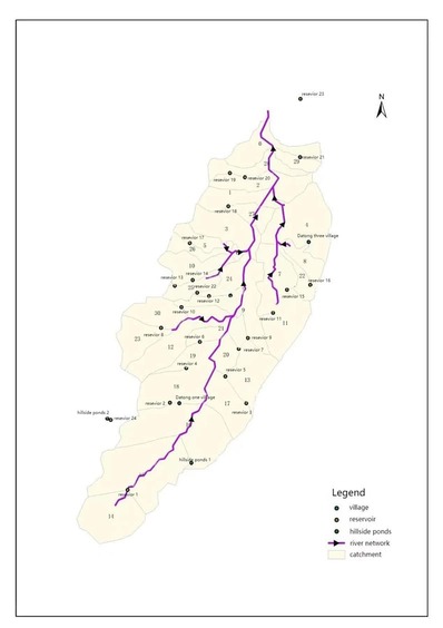
Figure 4: Sub-basin delineation.
Rainfall data and analysis: The research analysis of rainfall characteristics within the designated study area. Spanning the interval from 2016 to 2023, the study employs a continuous and cumulative rainfall dataset collected at a 5-minute resolution. An analytical approach has been employed, encompassing quality control measures, identification and treatment of outliers, an intensive investigation into rainfall intensity patterns for the six and 24-hour periods, and a comprehensive comparative assessment of distinct rainfall distributions. Notably, the watershed experiences a prominent wet season extending from March to September each year, accounting for a substantial portion of approximately 85% of the total annual precipitation. A graphical representation elucidates this phenomenon, portraying a comparative juxtaposition of yearly wet season rainfall distributions, enriched by a normalization procedure that enhances the interpretability present (Figures 5-7).
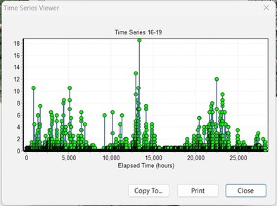
Figure 5: 2016-2019 rainfall distribution in hours interval.
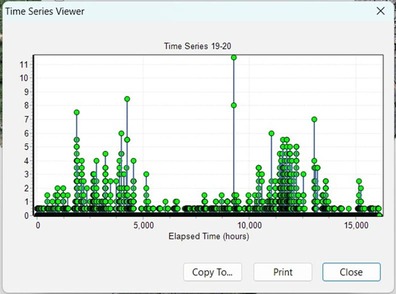
Figure 6: 2019-2021 rainfall distribution in hours interval.
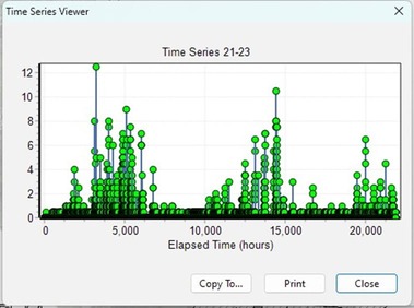
Figure 7: 2021-2023 rainfall distribution in hours interval.
Additionally, a detailed examination of yearly rainfall depths underscores significant trends. Specifically, the year 2021 emerges as the most pluvial year, marked by elevated rainfall depths. However, a subsequent decline in rainfall depths in the following year is indicative of a transition into a drought period. These observations underscore the temporal variability of rainfall patterns and offer critical insights into the interplay between climate factors and hydrological dynamics, substantiating the necessity for adaptive water resource management strategies (Figure 8).
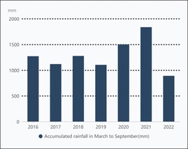
Figure 8: 2016-2022 rainfall.
Reservoir Interaction: The operation of hill reservoirs presents a formidable challenge, hinging on the intricate interplay of two pivotal factors: storage efficiency and the sudden influx of flash floods. This intricate balance underscores the need for an adept solution that can judiciously manage reservoir storage levels while ensuring safety and averting the intensification of flash flood risks—a complex endeavor that requires a meticulous engineering perspective.
Central to the operational complexity of hill reservoirs is the imperative of storage efficiency. The reservoir’s storage capacity essentially dictates its ability to accommodate water for a gamut of purposes—ranging from agricultural irrigation and domestic supply to flood control. Harnessing storage effectively ensures that the reservoir can fulfil its designated functions while concurrently mitigating water scarcity during dry spells. However, optimizing storage levels for maximal efficiency necessitates a conscientious weighing of potential downstream implications, particularly in the face of torrential downpours.
Concomitantly, the influx of flash floods constitutes a formidable operational challenge. In regions characterized by undulating terrains, abrupt and heavy rainfall events can catalyze rapid surface runoff, engendering a surge in water levels within rivers and streams. This accelerated hydraulic response can potentially overwhelm the reservoir’s holding capacity, culminating in a breach of the reservoir’s storage ceiling, and by extension, its designed flood limit. Such a scenario precipitates spillage and resultant downstream inundation—a sobering reminder of the need for robust mechanisms to effectively manage flash flood inflows.
Notably, augmenting the arsenal of solutions, the modification of the stage storage curve, and the integration of real-time operation come to the fore. The strategic adaptation of the stage storage curve implies a dynamic recalibration of storage capacity allocation within designated water level thresholds. By bolstering storage capacity during inclement weather, the surge of peak flows can be deftly attenuated, thus mitigating downstream flood risks with a predictive edge. It is imperative, however, that such adaptations remain responsive to the capricious nature of real-time weather events, necessitating an integrated approach that hinges on accurate, up-to-the-minute forecasts and hydrological data.
Moreover, the implementation of real-time operation stands as a linchpin of the solution. Harnessing real-time data derived from comprehensive monitoring networks empowers reservoir operators to calibrate outflow rates in direct response to evolving conditions. This real-time responsiveness not only facilitates precise control of reservoir levels but also enables the reservoir’s adaptive accommodation of ever-fluctuating rainfall and inflow patterns. This facet of the solution further underscores the imperative of coupling advanced prediction models and datadriven decision support systems to effectuate an operation strategy of unparalleled precision.
Grappling with the multifaceted challenge of hill reservoir operation necessitates a multidimensional understanding of storage efficiency, flash flood dynamics, dynamic stage storage curve adaptations, and real-time operation. The convergence of cutting-edge technologies, up-to-the-minute data streams, and predictive modeling underpins the capacity to expertly navigate the intricate hydrological landscape. In a landscape where the stakes are inherently high, forging a harmonious equilibrium mandates an amalgamation of engineering acumen, data-driven discernment, and a proactive ethos that collectively culminate in the judicious management of hill reservoirs and the concomitant minimization of flood risks.
As runoff progresses downstream, a portion of it can be intercepted by the reservoir. The simulation model effectively predicts how water is channeled into the reservoir, factoring in its storage capacity and the inflow originating from various sub-basins. Reservoir nodes are defined, and sub-basins are identified based on topographical features within the model. Rainfall simulations within these basins lead to the computation of runoff generation for each sub-basin, considering delineation and parameter settings. Subsequently, the runoff volume for each sub-basin is quantified. The model then considers diverting a portion of this runoff into the reservoir, taking into account the reservoir’s capacity.
This simulation encompasses the reservoir’s storage dynamics, including design and outflow regulations encompassing filling, emptying, and discharge processes. Adhering to the reservoir’s outflow rules and capacity, the model intelligently extracts an appropriate volume of water from the reservoir, factoring in downstream runoff conditions. This comprehensive simulation accurately portrays the reservoir’s regulation and water supply functions downstream.
In the context of hilly landscapes, reservoir storage modifications yield multifaceted implications for hydrological systems and watershed management strategies. Hill reservoirs transcend their role as mere storage facilities. They assume pivotal roles in flood control, flash flood risk mitigation, water resource assessment, and the preservation of ecological water supply. Collectively, these roles contribute to the comprehensive management and sustainability of hill watersheds. The unique terrain characteristics amplify the significance of these reservoirinduced impacts.
Central to hill reservoirs is their function in flood mitigation and regulation. Given the susceptibility of hilly terrains to rapid runoff and steep gradients, reservoir storage capacity and outflow regulations can be adaptively managed to moderate downstream flow rates during heavy rainfall events. This dynamic approach, involving storing excess water and releasing it in a controlled manner, mitigates peak flows and flood peaks. Such adaptive flood management not only shields downstream areas but also diminishes flood-induced disasters, enhancing overall watershed resilience.
Beyond flood-related roles, hill reservoirs significantly contribute to sustaining low flows during dry or drought periods. Controlled release of stored water during scarcity ensures supplemental downstream water supply, particularly beneficial for supporting river ecosystems and preserving aquatic habitats, thereby mitigating potential ecological disturbances. Additionally, strategic manipulation of reservoir storage and water supply rules optimizes water resource allocation, catering to the diverse needs of downstream communities, agriculture, and industry. This adaptive approach effectively addresses water scarcity challenges and fosters sustainable water utilization practices.
The reservoir’s influence extends to enhancing water quality within hill watersheds. Mechanisms like sedimentation, clarification, and biological interactions facilitate the removal of suspended particles and pollutants from incoming water. This process bolsters water purification efficacy and safeguards clean, thriving ecosystems. Thus, the reservoir emerges as a vital component for safeguarding water sources, minimizing pollution inputs, and maintaining ecological balance within the watershed.
The alteration of reservoir storage patterns in hilly landscapes initiates a cascade of impacts that go beyond conventional storage functions. By regulating floods, mitigating flash flood risks, sustaining low flows, optimizing water allocation, and elevating water quality, these reservoirs play a central role in shaping the hydrological and ecological dynamics of hill watersheds. These adaptive functions align harmoniously with sustainable water resource management, ecosystem preservation, and the resilience of communities in these often vulnerable terrains. As the runoff flows downstream, a portion of it may be captured by the reservoir. The model simulates how water is diverted into the reservoir, considering its capacity and the inflow from respective sub-basins. Within the model, reservoir nodes are defined, and sub-basins are delineated based on topographical features. After simulating rainfall within the basins, the model calculates the runoff generation for each sub-basin, considering the delineation and parameter settings. Based on the model calculations, the runoff volume for each sub-basin is determined. Considering the reservoir capacity, the model considers diverting a portion of the runoff into the reservoir.
The reservoir storage process is simulated based on design and outflow rules, including the filling, emptying, and discharge processes of the reservoir. Based on the reservoir’s outflow rules and capacity, the model extracts an appropriate amount of water from the reservoir while accounting for the downstream runoff conditions. This allows for simulating the regulation and water supply functions of the reservoir downstream. In the context of hill landscapes, the modification of reservoir storage holds multifaceted implications for the hydrological system and watershed management strategies. The functions and impacts of hill reservoirs extend beyond their role as mere storage facilities, encompassing crucial aspects such as flood control, flash flood risk mitigation, water resource assessment, and the preservation of ecological water supply. These aspects collectively contribute to the holistic management and sustainability of hill watersheds, where the unique terrain characteristics amplify the significance of these reservoir-related impacts.
One essential function of hill reservoirs is flood mitigation and regulation. Given the inherent susceptibility of hilly terrains to rapid surface runoff and steep gradients, the reservoir’s storage capacity and outflow regulations can be dynamically adjusted to manage downstream flow rates during heavy rainfall events. This adaptive approach, by storing surplus water and subsequently releasing it in a controlled manner, attenuates peak flows and flood peaks. This proactively managed flood regime not only safeguards downstream areas but also minimizes the potential for floodinduced disasters, thereby bolstering the overall resilience of the watershed in the face of extreme weather events.
Moreover, hill reservoirs play a pivotal role in mitigating flash flood risks, which are particularly pronounced in terrains characterized by sudden, intense rainfall and rapid runoff. The reservoir’s capacity to temporarily store excess runoff offers a mechanism to counteract the rapid influx of water downstream, significantly reducing the likelihood and intensity of flash floods. This mitigation strategy has far-reaching implications, protecting both human settlements and vital ecological systems from the potentially catastrophic impacts of flash floods.
Beyond flood-related functions, hill reservoirs significantly contribute to maintaining low flows during dry or drought periods. By controlled release of stored water during times of scarcity, these reservoirs ensure a supplementary water supply downstream [14]. This is particularly pertinent for supporting river ecosystems and safeguarding aquatic habitats, thus mitigating potential ecological disruptions. Additionally, the strategic manipulation of reservoir storage and water supply rules enables the optimization of water resource allocation, catering to the diverse needs of downstream communities, agricultural activities, and industrial processes. This adaptive approach effectively addresses water scarcity challenges and fosters sustainable water utilization practices.
The reservoir’s role in enhancing water quality within hill watersheds is equally significant. Through mechanisms such as sedimentation, clarification, and biological interactions, the reservoir aids in the removal of suspended particles and pollutants from incoming water. This process contributes to the improvement of water purification effectiveness and the preservation of clean and healthy ecosystems. The reservoir thus emerges as a critical component in the protection of water sources, the minimization of pollution inputs, and the maintenance of ecological integrity within the watershed.
The modification of reservoir storage in hill landscapes triggers a cascade of impacts that extend well beyond conventional water storage functions. By regulating floods, mitigating flash flood risks, maintaining low flows, optimizing water allocation, and enhancing required water quality, these reservoirs play a pivotal role in shaping the hydrological and ecological dynamics of hill watersheds. The adaptive functions align harmoniously with the sustainable management of water resources, the preservation of ecosystems, and the resilience of communities inhabiting these often-vulnerable terrains.
With these two design criteria, this study modifies all of 22 reservoir stage storage curves with the inflow basin’s hydrological properties to optimize the storage operation by the balance between storage efficiency and flood overtopping risk with the full spectrum of design rainfall depth. Then implement the optimized model with the 2022 drought year’s continuous rainfall data and compare the model stream flow result with the stream record. The comparison shows the optimized model will improve the water resource efficiency by approximately 32%.
Model results and calibration process
Two steam observations flumes with 16 rainfall events were recorded during the study period. One stream observation flume is located near the outlet of the watershed, and the other is located upstream of the watershed approximately 1/3 of the mainstream which before the other two sub-stream flows confluence point. Two of the 16 rainfall events stream observation data were eliminated because of outlier data treatment. To calibrate and evaluate the hydrological model results, this study selects the Nash-Sutcliffe Efficiency (NSE) method to analyze the modeling errors. NSE is a widely used objective function that assesses the performance of a hydrological model by comparing the simulated values to the observed data [12]. It measures the proportion of the total variance in the observed data that is captured by the simulated data. Figures 9 and 10 present the continuous stream flow model result from 3/1/2019 to 1/1/2021 for both observation flumes.
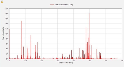
Figure 9: Upstream flume observation flume stream flow record from 3/1/2019 to 1/1/2021.
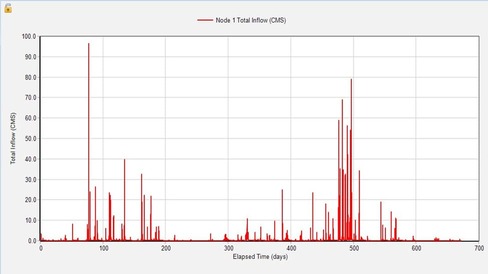
Figure 10: The outlet flume observation flume stream flow record from 3/1/2019 to 1/1/2021.
The formula for calculating NSE is as follows:
Where:
Observed = the observed streamflow value.
Simulated = the simulated streamflow value from the model.
Observed mean = the mean of the observed streamflow values.
The Nash-Sutcliffe Efficiency (NSE) metric spans from negative infinity to 1, with higher values indicating superior model performance. An NSE score of 1 signifies an ideal agreement between simulated and observed values, while values below 0 suggest that the mean of the observed data would provide more accurate predictions than the model. Within the scope of this study, the NSE values for the downstream flume range from 78 to 90%. On the other hand, the upstream observation station demonstrates more favorable values, ranging between 0.86 and 0.94. Through a detailed comparison between these two sets of data, the investigation reveals that the hydrological condition of the upstream basin is comparatively simpler than that of the entire watershed. This distinction is attributed to the upper basin’s limited three-reservoir routing, steeper terrain, and a higher degree of homogeneity in land use, surface roughness, and impervious characteristics across sub-basins. The calculation and analysis of NSE are depicted in Table 2. Additionally, the table provides a comprehensive presentation of the two sets of data for easy reference and comparison (Figure 11) [16-19].
|
Number |
1 |
2 |
3 |
4 |
5 |
6 |
7 |
8 |
9 |
10 |
11 |
12 |
13 |
14 |
|
Upper watershed |
0.78 |
0.88 |
0.87 |
0.86 |
0.82 |
0.9 |
0.85 |
0.83 |
0.89 |
0.81 |
0.8 |
0.81 |
0.85 |
0.83 |
|
Downstream watershed |
0.89 |
0.91 |
0.87 |
0.92 |
0.91 |
0.87 |
0.86 |
0.93 |
0.89 |
0.88 |
0.88 |
0.92 |
0.94 |
0.92 |
Table 2: NSE metric for both observations with 14 selected rainfall events.
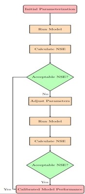
Figure 11: The flow Chat to demonstrate the NSE analysis process.
Conclusion
This study presents a comprehensive water resource assessment and optimization system designed to enhance water supply and irrigation management within the hill area of southern China. By addressing critical concerns such as drought vulnerability, hill flash flood prediction, and reservoir operation optimization, the system seamlessly integrates GIS, hydrology and hydraulic modeling, and SCADA technologies.
The system’s architecture consists of distinct components that synergistically contribute to its functionality. A GIS model plays a pivotal role in identifying reservoir watersheds, while a hydrology model facilitates the integration of vital reservoir data. The incorporation of hydraulic modeling enables accurate flow simulation and storage optimization. The continuous stream of real-time data from strategically placed SCADA sensors establishes a dynamic simulation database, enabling real-time monitoring of flow, and depth, and providing spatial and temporal rainfall forecasts. Notably, during periods of drought, the system transforms into a valuable decision-support tool.
On the system implementation, this study generates the hydrological model with GIS, BIM, and SCADA stream records. Model evaluation is the use of statistical metrics, NSE, to quantify the goodness of fit between the simulated and observed data. The models integrity of NSE is in the range of 78 to 90%. The optimized model shows the water resource improvement to approximately 30% on year of 2022 drought year.
References
- Yin X, Huang M, Zou Y (2018) Changes in Rice Yield Stability in Southern China from 1949 to 2015. Agricultural & Environmental Letters 3: 170038.
- Wang W, Yu Z, Zhang W, Shao Q, Xu J (2014) Responses of rice yield, irrigation water requirement and water use efficiency to climate change in china: historical simulation and future projections. Agricultural Water Management 146: 249-261.
- Sun J, Zhang FQ (2017) Daily extreme precipitation and trends over China. Science China Earth Sciences 60: 2190-2203.
- Liu J, Liu HL, Liu R, Amin MGM, Ding X (2018) Water Quality in Irrigated Paddy Systems. IntechOpen.
- Rahmani B (2021) GIS and Remote Sensing in Water Resource Engineering. Kardan Journal of Engineering and Technology 3: 42-61.
- Carrara A, Guzzetti F, Cardinali M, Reichenbach P (1999) Use of GIS technology in the prediction and monitoring of landslide hazards. Natural Hazards 20: 117-135.
- Todorovic M, Steduto P (2003) A GIS for irrigation management. Physics and Chemistry of the Earth, Parts A/B/C 28: 163-174.
- Bouman BAM, Humphreys E, Tuong TP, Barker R (2007) Rice and water. Advances in Agronomy 92: 187-237.
- Cheng JYC (2019) Introduction of Level Spreader Systems and Evaluation of the Land Imperviousness for Storm water Management. J Earth Environ Sci 7: 172.
- Guo Y, Senior MJ (2006) Climate model simulation of point rainfall frequency characteristics. J Hydrol Eng 11: 547-665.
- Lozoya C, Mendoza C, Mejia L, Quintana J, Mendoza G, et al (2014) Model Predictive Control for Closed-Loop Irrigation. IFAC Proceedings Volumes 47: 4429-4434.
- Cheng JYC (2011) Modification of kinematic wave cascading model for low impact watershed development. Dissertations & Thesis - Gradworks. University of Colorado.
- Kalboussi N, Roux S, Boumaza K, Sinfort C, Rapaport A (2020) About modeling and control strategies for scheduling crop irrigation. IFACPapersOnLine 52: 43-48.
- Acharya S, Pandey A, Mishra SK, Chaube UC (2016) GIS based graphical user interface for irrigation management. Water Supply 16: 1536-1551.
- Massey JH, Walker TW, Anders MM, Smith MC, Avila LA (2014) Farmer adaptation of intermittent flooding using multiple-inlet rice irrigation in Mississippi. Agricultural Water Management 146: 297-304.
- Lee J (2022) Evaluation of Automatic Irrigation System for Rice Cultivation and Sustainable Agriculture Water Management.Sustainability 14: 11044.
- Mallareddy M, Thirumalaikumar R, Balasubramanian P, Naseeruddin R, Nithya N, et al. (2023) Maximizing Water Use Efficiency in Rice Farming: A Comprehensive Review of Innovative Irrigation Management Technologies. Water 15: 1802.
- Szelag B, Łagód G, Musz-Pomorska A, Widomski MK, Stránský D, et al. (2022) Development of Rainfall-Runoff Models for Sustainable Stormwater Management in Urbanized Catchments. Water 14: 1997.
- Sun T, Cheng W, Abdelkareem M, Al-Arifi N (2022) Mapping Prospective Areas of Water Resources and Monitoring Land Use/Land Cover Changes in an Arid Region Using Remote Sensing and GIS Techniques. Water 14: 2435.
© by the Authors & Gavin Publishers. This is an Open Access Journal Article Published Under Attribution-Share Alike CC BY-SA: Creative Commons Attribution-Share Alike 4.0 International License. Read More About Open Access Policy.