Faults, Joints, Uplift Mechanism-Orogeny and Geomorphology
Authors: Vaios Avdis*
*Corresponding Author: Vaios Avdis, Former IGME Athens, Greece
Former IGME Athens, Greece
Received Date: 31 May, 2022
Accepted Date: 09 June, 2022
Published Date: 16 June, 2022
Citation: Avdis V (2022 Faults, Joints, Uplift Mechanism-Orogeny and Geomorphology. J Earth Environ Sci 5: 195. DOI: https://doi.org/10.29011/2577-0640.100095
Abstract
So far the high-angle faults have been ignored by geoscientists, since each one is not mappable. Their additive result though is very important. Faults make the rocks outcrop that is, cause the uplift and form domes, mountains (Orogeny). Numerous faults transect the bedding planes of the sedimentary and metamorphic rocks with small or large-scale displacement, therefore the faults make bedding discontinuous.
In addition, several scientists have mistaken the lineaments as bedding, since the lineaments look like bedding traces. Their extrapolation led to erroneous interpretations. The plate tectonics is acting at depth and not on the surface. The collision of plates creates various changes such as folds, metamorphism cleavages, schistosity, crystal growth, obduction, subduction and others. Some of these changes need space. The only available space is upwards. The folds are pushing the rocks differentially upwards forming fold-like structures, the mountains. The uplift is an upward movement, which is usually differential, above the deepest point of the sea in the vicinity. When the rocks outcrop, above the sea level, erosion follows, and more or less, the primary shape is maintained. The occurrence of suitable marker horizon witnesses the amount of erosion. Some examples from Greece, Switzerland and the United States prove that the topography is primarily tectonic despite the erosion. The high-angle faults of small dip-slip displacement are the main uplift and orogenic mechanisms. The ignorance of the numerous high-angle faults and the subsequent uplift and erosion, made people to invoke several unconformities, thrusts and nappes.
Keywords: Faults; Joints; Uplift mechanism; Orogeny; geomorphology
Introduction
Fieldwork has proven that the topography is primarily tectonic because of the numerous high-angle faults in two sets of small dip-slip displacement perpendicular to each other [2]. A lot of confusion exists about faults, joints, uplift, orogeny and geomorphology. In clearings devoid of soil, we can see a chocolate-like pattern of two lines perpendicular to each other. These lines consist of segments of cracks. The cracks display small displacement and are usually called Joints. Some of these “joints” present considerable displacement. If the latter are in a row form a quasi-straight line observed from a distance, aerial photographs and satellite images, usually called faults. The two sets of faults together with the top and the base faces are forming prisms which, in this paper, will be called Tectonic Units (TU). For simplicity, they are assumed to be perfect quadrangle prisms of equal size, despite that they are not as such and hexagonal prisms are frequent in volcanics.
The uplift mechanism and the orogeny are, the result of faulting in two sets perpendicular to each other. The geomorphology is, primarily the result of faulting in two sets of vertical to sub-vertical faults. If the erosion is uniform the shape of the dome remains proportionally the same. The streams, the rivers, the glaciers, the lakes and even the sea, follow primarily the topography. Later on the erosion is intensive especially in floods and the waves.
Previous Work about Faults, Joints, Uplift-Orogeny and Geomorphology
Holmes defined the fault as a fracture plane, along which the rocks have been relatively displaced. The vertical and horizontal displacement can reach up to approximately 300m and 16 km respectively. He considered that joints are the cracks and fractures we see in cliffs and quarries and claimed that these cracks and fractures are normal to bedding if the rocks are horizontal [3].
Ramsay(1967) related the formation of faults and joints with folding. The formation of “joints” was related to the distribution of stress trajectories because of horizontal compression [4].
Price(1966) defined the faults as “planes of fracture which exhibit obvious signs of differential movement of the rock mass on either side of the rock mass”. The same author defined the joints as “cracks and fractures in rock along which there has been extremely little or no movement”. He also claimed that the joints outcrop in incompetent rocks (even during the sedimentation). He supported that the formation of folds is simultaneous to the formation of faults [5].
Anderson(1925) distinguished three kinds of faults dynamically with respect to the direction of the principal stress (σ1) to cardinal points. (Normal, Strike-slip Faults and Thrusts).
Britannica encyclopedia described “Uplift, in geology, as the vertical elevation of the Earth’s surface in response to natural causes. Broad, relatively slow and gentle uplift is termed warping, or epeirogeny, in contrast to the more concentrated and severe orogeny, the uplift associated with earthquakes.
England & Molnar, 1993, considered that a sort of buoyancy elevates the rocks above the average sea level (a.s.l). Geomorphology (γαία=earth, + μορφή=shape, + λόγος=study, science) a definition by British Society of Geomorphology” includes the processes for the formation of landforms.) is “the study of the” Landforms produced by erosion or deposition, as rock and sediment is worn away by earth-surface processes and transported and deposited to different localities”.
The Author’s Views
In the author’s mind, a fault is not a fracture plane (Holmes 1965) but several fracture planes. These fracture planes may form a quasi-straight line and as such are marked on various geological maps. In other words, the faults are an optical illusion of many faults in a row or almost in a row. The faults and joints are the same thing and they will be called faults. The Joints are mainly the outcropping parts of faults, in engineered road sections, of any orientation, in competent rocks; we observe that there are two sets of (vertical to sub-vertical) faults of small or large dip-slip displacement. Α series of faults in two directions form straight to quasi-straight lines.
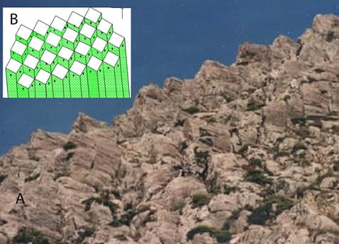
In addition as these faults occur in two sets perpendicular to each other, they form prisms with four lateral (or in volcanic rocks, locally six) faces, excluding top and bottom faces. If the rocks are homogeneous and brittle, the TUs are almost perfect prisms.
Faults of small displacement where the hanging wall has been removed by manmade works have been interpreted as major faults. The use of the terms “major and minor” faults is doubtful. The displacements by Holmes are overestimated. The TUs If the rocks are neither homogeneous nor of high brittleness are irregular [2].
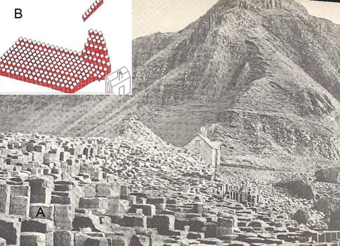
The TUs of crystalline rocks are also similar to the TUs of high-angle faults in the volcanic rocks in N. Ireland. In the Giant’s Causeway of N. Ireland, we observe the outcropping faults forming prisms.
According to the international geological literature, the formation of these prisms is the outcome of sudden freeze. It is widely accepted that the cracks are comparable to the mud cracks. The shapes of mud cracks formed are irregular and only superficial. In my mind these prisms are not related to any temperature variation, but are tectonic and their formation occurred after their solidification (Figure 1). In addition, from empirical experience, it is well known that blacksmiths often immerse iridescent iron (senso lato a rock) into cold water and never breaks into pieces.
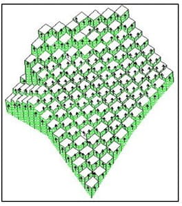
The two sets of faults result in the formation of domes of various shapes (Figure 2). Standing up on these domes one cannot see the thickness of a rock formation because he/she has access only to the surface of the dome and repeatedly part of the fault “mirrors”.
The formation of domes is itself the uplift mechanism and in turn, the orogeny. The uplift and orogeny are not contrasting mechanisms but identical. They are both purely brittle ones. This is strengthened from the observation that in the following cases, even in competent rocks we do not see such vertical to sub-vertical faults.
- No faults in recent competent continental sediments. (Uplift mechanism is not required for them to outcrop) b. No faults in recent volcanic rocks
- Faults are replaced by cataclastic flow locally, even in brittle competent rocks.
- In vertical strata one set of the vertical faults and bedding planes are indistinguishable each other.
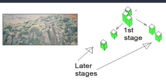
We must keep in mind that the TU are at the beginning attached. After the uplift, the confinement of the rocks is decreased gradually. Components of gravity make the TUs creep downslope (Figure 3).
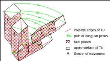
It is important to emphasize that, a close up observation of the lineaments (observed from a distance, air photos and satellite images), of traces of planes, in a row, often mistaken as bedding. These lineaments are of three kinds:
- The contact (usually covered by soil and debris) of hanging wall to the footwall of successive TUs, (the most frequently observed)
- The traces of upper surface of successive TUs, not necessarily in a row and sometimes locally eroded.
- Distinct traces of layers transected by numerous faults in two sets perpendicular to each other.
In any case, the bedding planes are discontinuous and cannot be used for the correlation of the numerous TUs. Two simple models can help the reader to visualize the uplift mechanism (Figure 4). The card model depicts one set of faults. Each piece depicts a TU. Standing up on the top faces of both these models one cannot estimate the thickness of a formation.
The erosion of domes brings older rocks in higher elevation than younger rocks, because the erosion is faster in higher elevations (because of their higher potential energy) If we ignore the small displacement faults we are forced to invoke thrusts, nappes and/ or unconformities. In addition, the lack of juxtaposition, of various adjacent highlands make the field geoscientists to invoke again thrusts nappes and/or unconformities. The occurrence of folds in the field and of the non-mappable faults misled the geoscientists. They considered the uplift as the result of movement against gravity because of movement upwards at depth as an entire unit.
Two simple models, A Playing card model. Each card depicts two parallel faults A matches model. Each piece depicts a TU.
The uplift will be defined in this work as the movement against gravity above the deepest point of the sea in the vicinity. The differential movement upwards is the result of faults, which are associated with earthquakes. After uplift there are only two kinds of forces on domes: A perpendicular gravity force (components of gravity cause landslides of small and large scale). Differential movements upwards cause the formation of high-angle faults and in turn the formation of domes (mountains). The orogenesis
(όρος=mountain + γένεσις=birth, formation) is again a brittle process. The folds contribute to orogeny but it is impossible to follow the bedding. In addition, the fold peaks and hinges rarely coincide with the mountain peaks and ridges.
The folds we see in various formations nowadays are inherited from the formation of folds when these were at depth and now they have uplifted. In incompetent rocks, there are no faults but the rocks undergo cataclastic flow, since the topography of the adjacent highlands is primarily tectonic. It is obvious that the incompetent rocks, too, form domes primarily. Small area outcrops of a formation have been erroneously interpreted as intercalations despite the fact they are outlined by faults. Marker horizons also outcropping in various elevations have been mistaken as alternations. These are mostly the combined result of doming by faulting and erosion.
When the rocks are homogeneous and very brittle, the TUs are perfect 4-gonal or 6-gonal prisms with the upper face and their base. In less brittle rocks, these prisms are irregular. The size of the TU in brittle rocks varies considerably. Most of the horizontal length and width of prism faces are more or less in the range of 50 cm to 10 meters. The faults are associated with earthquakes. The depth of TUs is probably associated with the ductile /brittle transition, provided that the whole stratigraphic column consists of competent rocks. This usually coincides with foci of many earthquakes occurring in a depth range from ~ 7 km to 12 Km. The foci of some earthquakes occurring at a depth up to 50 km, are probably associated with thrusts and strike-slip faults.
The cohesion and adhesion of rocks make them move horizontally, passively even before and after uplift. This is consistent to the general shape of the continents nowadays. Plate tectonics is beyond the scope of this work but it is obvious that the plates are moving, (converge or diverge) at depth and not on the surface. Although accurate geodetic methods prove that the continents move relatively to each other, the vertical or subvertical faults are not associated with rifting and extension. The sub-vertical faults do cause extension in one direction. In an adjacent highland or the opposite side of the same highland it is an extension of opposite direction which may counterbalance the previous one. The two vectors of extension may counterbalance. The perimeter of a section of a highland is only extended. Sometimes folds can be good marker horizons of faults (Piessa, Kea, Greece & Ferderthorn, Switzerland).
Strike-Slip and Thrust Faults
Most of faults are vertical to sub-vertical due to differential stresses upwards. In geological maps, we can see erroneously several thrusts and strike-slip faults. The strike-slip faults have a vertical to sub-vertical fault plane. If there are slickensides, they are horizontal. The thrust fault plane is a low-angle one (~30°) due to horizontal stress. A prerequisite for the formation of such faults (Strike-slip and thrust faults) is the horizontal stress. Therefore, they predate uplift.
In the field, we observe many folds, including recumbent folds. The folds require horizontal compressional stress during their formation. Therefore, there are thrusts and strike-slip faults in an area. They are inherited in the rocks from the time they were in intermediate rheological conditions. The numerous vertical to sub-vertical faults transect the wrench and thrust fault planes. So they make them indistinguishable from the traces of numerous vertical to sub-vertical faults, on the surface. All these can only be distinguished in sections if there are conspicuous slickensides which make them distinguishable from the vertical faults. Very often, two or more TUs result in the formation “pseudo-thrusts” due to rotation because of components of gravity (toppling).
STUDY CASE: GREECΕ
Tataris & Christodoulou (1969) mapped, the studied area of Gigilos. They ignored the numerous high-angle faults so they invoked five (5) unconformities in order to interpret the geology of the Alikianos sheet, in the area of Lefka Mt near the well-known Samaria gorge.
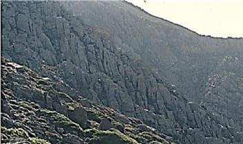
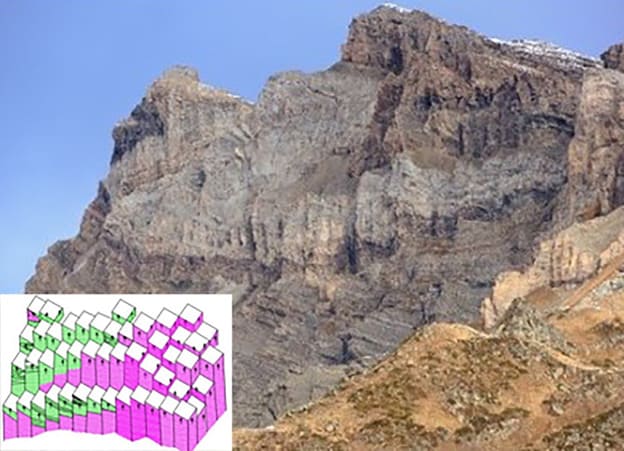
We can see successive faults of small dip-slip displacements in Chania, Crete (Gigilos Mt), of high-angle faults assuming the top face of TUs as a marker horizon.(seeFigure 6)
If one does not consider the structures, which result from these high-angle faults of small dip-slip displacement, might invoke thrusts, nappes and/or unconformities. This is similar to the card model (Figure 4) Careful inspection of the area indicates faults perpendicular to the series of the conspicuous ones of the Gigilos area we can see several tectonic “steps” in two directions perpendicular to each other (Figure 5), similar to the matches model figure 4.
Study Case: Alps (Switzerland)
Alps
Voluminous geological literature exists about the geology of the Alps, since the “discovery “of gigantic folds and “over thrusts” by Escher van der Linth [5] many geologists tried to unravel the geology of the area. Schmidt et al. studied the area geologically and geophysically [6]. They found several strike-slip faults and thrusts. They ignored the numerous vertical to sub-vertical faults. Their cross- section is an intricate one, based on folding and thrusting. Schmidt et al. 7] suggest that a wedge pushed the rocks of the Alpine range northwards. In addition, they described strike-slip faults. Stampfli, et al. in a field-trip guide of Swiss Alps describe several nappes and present an intricate cross-section. Probably because of the lack of Juxtaposition among adjacent highlands and the faster erosion of the higher elevations, so older rocks outcrop topographically higher than younger rocks. They also present several anticlines and synclines based mainly on the topography.
Most workers in the area of the Alps, describe a lot of nappes, based on the occurrence of recumbent folds which “senso lato” are nappes. For example, the Err nappe is a recumbent fold seen in the field. They suggest that nappes are associated with the deformation, the schistosity, cleavages, metamorphism (crystal growth), during and after the uplift.
They erroneously extrapolate the “bedding”. Their work is based on the cleavages and the schistosity and fold phases, the paleogeography, the lithology etc. Most of these structures were formed when the rocks were at depth in ductile (plastic) rheological conditions. On the other hand, the uplift is purely a brittle process and has nothing to do with the above structures. The whole area of the Alps uplifted at different times and the uplift is not uniform. Of course, there is erosion faster in the highest elevations (due to higher potential energy, see above) and locally, for various reasons may be faster (e.g. local storms) and the different times of outcropping.
Voluminous geological literature exists about the geology of the Alps, since the “discovery “of gigantic folds and “over thrusts” by Escher van der Linth (1841) many geologists tried to unravel the geology of the area. Schmidt et al (1996) studied the area geologically and geophysically. They found several strike-slip faults and thrusts. They ignored the numerous vertical to subvertical faults. Their cross- section is an intricate one, based on folding and thrusting. Schmidt et al. (1999) suggest that a wedge pushed the rocks of the Alpine range northwards. In addition, they described strike-slip faults. Stampfli et al (2000) in a field-trip guide of Swiss Alps describe several nappes and present an intricate cross-section. Probably because of the lack of Juxtaposition among adjacent highlands and the faster erosion of the higher elevations, so older rocks outcrop topographically higher than younger rocks. (see above) They also present several anticlines and synclines based mainly on the topography.
Most workers in the area of the Alps ,describe a lot of nappes, based on the occurrence of recumbent folds which “senso lato” are nappes. For example, the Err nappe is a recumbent fold seen in the field. (Stampfli (editor) et al 2001 and Bousquet et al (2002) Mohn (2005) Wikipedia, (2020) support the occurrence of nappes.
They suggest that nappes are associated with the deformation, the schistosity, cleavages, metamorphism (crystal growth), during and after the uplift.
They erroneously extrapolate the “bedding”. ( see above) Their work is based on the cleavages and the schistosity and fold phases, the paleogeography, the lithology etc. Most of these structures were formed when the rocks were at depth in ductile (plastic) rheological conditions. On the other hand the uplift is purely a brittle process and has nothing to do with the above structures. The whole area of the Alps uplifted at different times and the uplift is not uniform. Of course, there is erosion faster in the highest elevations due to higher potential energy,(see above and locally) for various reasons may be faster (e.g.local storms) and the different time of of outcropping.
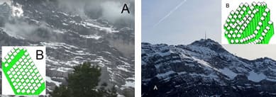
The result of combined, doming by faulting and erosion has been misinterpreted as folding.( Each dome and mountain range is primarily the result of the two (at least) sets of faults. In the area of Grindelwald we see the formation of a slope of the dome. We also see the formation of lineaments (see above). Road sections, for obvious reasons, follow the contours of the mountains and the effect of one set of faults usually seem to be negligible. However, in caves, quarries and mines we can see considerable displacement, if the rock succession remains intact, because of the man-made works, as there is no confinement. The additive result is, in any case, very important. All previous workers ignored the significance of the numerous high-angle faults of small dip-slip displacement for two reasons the above-mentioned changes (folds, schistosity, cleavage etc.) predate uplifting. After uplift, there is not lateral compression on the rocks, since the water, air/rock interface do not exercise any stress (see above) The P-T conditions are not high enough for ductile deformation. But these are affected by faulting and the bedding cannot be extrapolated. The so called Mythen Klippen, As it was, mentioned above, the rocks after uplift behave in a semi-brittle to brittle manner are not tectonic klippen but the combined result of doming (by faulting) and erosion. The “Hohe Tauern window” also is not a te ctonic one but the result of doming and erosion. The Niesen & Wildhorn “nappes” are not nappes and thrusts, but the result of mistaking the slopes as crosssections. Only the Err nappe and some recumbent folds can be considered as nappes (Figure 6) [20,21].
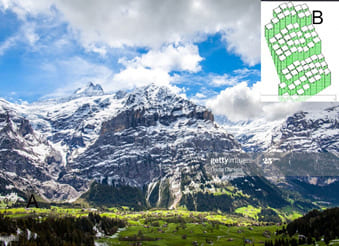
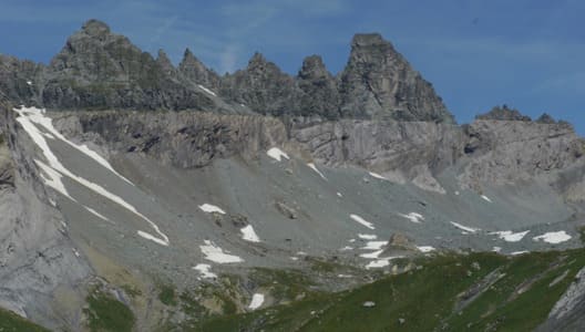
We see some examples from the Swiss Alps. The highest point in Swiss Alps is the Matterhorn is a dome by faulting in two sets. It was claimed that it is the result of incision by “widespread glaciers”. Nearby it is obvious that there are traces of glaciers. But the glaciers follow the topography. The boundaries of glaciers, of course have been incised. If one considers the effects of the two sets of vertical to sub-vertical faults it proves that the Matterhorn used to be a tectonic dome. Erosion confuses the primary formation. Snow is a good indicator of the tectonic “steps”. The rocks are frequently folded, sometimes by recumbed folds, but the mountains are the result of faulting Figure 11.
The Glarus “Nappe”
The case of Glarus nappe is the only one in which two units, can be seen in a cross-section. An underlying and an overlying one (Figure 12). Roth erroneously presents the flysch as an intercalation between limestone’s although it is faulted against the limestone’s. The flysch lies topographically lower than the limestone but stratigraphically higher. This proves that the movement took place after the uplift and the subsequent erosion, when there is no lateral compression.
We can also see (with reservation) on the other hand that the two units are affected by vertical- sub-vertical faults, but not all the faults are concordant to each other. The concordant ones post-date the movement of the overlying unit whereas the non-concordant ones indicate a different uplift history. Roth claims that the limestone was mylonitized. He, probably, means that there is a tectonic breccia (powder like) and not a shear zone mylonite (metamorphic). The Glarus nappe is a large-scale landslide in a different topography than todays. A similar example occurs on Mykonos, Greece, with clear “tectonic” contact where conglomerates overlie a granite with clear tectonic contact.
Study Case: The Colorado River Area (Grand Canyon)
The Geological literature of the Grand Canyon and its adjacent areas (Plateau, Valleys etc.) is voluminous. All the geologists agree that, the area of the Colorado River area is the result of erosion and uplift. Holmes considers the area of the Colorado River tributary as the result of erosion and an intercalation of various units by ignoring the high-angle faults. Jochems & Pederson consider the Grand Canyon is the result of uplift and erosion and the lithology of various rocks. In addition, continental drift vulkanism and climatic change contribute to the formation of the Grand Canyon. Joachim claims fluvial terraces are important landscape markers that contain information about incision, deformation, and climate change. Yet understanding their formation has long been a fundamental problem in geomorphology. Wood Bass described four anticlines. He estimated the thickness of sedimentary rocks c.600m. He recognized numerous normal faults, which were formed after the elevation. They consider the most important structures are the reverse faults and the folds. Runney considers the formation of Grand Canyon as the result of erosion by air and the Colorado River.
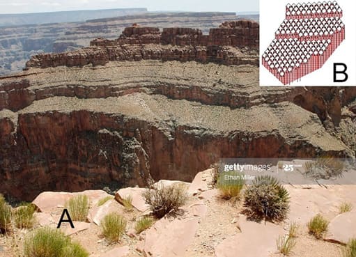
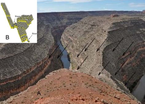
This is mainly tectonic primarily. The stratigraphic column by Ribokas (1994-2003) and Jenninng (2004) and others are erroneous. All previous authors who worked in the area of the Colorado River have ignored the occurrence of a plethora of vertical to sub-vertical faults of small dip-slip displacement in two sets. Two impressive examples prove the formation of domes by faulting (Figures 13 and 14).
Although there is erosion particularly during floods the Colorado River, area geomorphology is not mainly, the result of erosion. The riddle of the Colorado River area, in my mind, can be solved and simplified if one takes into consideration the two sets of faults occurring in the area.
Mathematical Interpretation
It is well known and supported by the majority of geologists that 2-3 plates collide in some areas. If the interlayer cohesion is negligible then differential horizontal movements take place. The rocks there, are confined all over, the temperature is high (the time unlimited) therefore the rocks there behave in a ductile manner. If we assume constant volume of the rocks, the horizontal contraction will result in a vertical extension where the rocks are less confined. The rocks at the uppermost crust (~10 km) behave rheologicallly, more or less, as brittle ones. Folding at depth will push upwards, the overlying rocks with the overburden weight and supported at the highest points of the folds at depth.
If we assume that an embryonic fold is formed at depth, due to the collision of two or more tectonic plates. The overlying brittle rocks will break when suitable conditions occur. We can treat the rocks elastic homogeneous thin plates where the overlying rocks load them uniformly. Type equation here.
Because the rocks are usually layered we can assume a thin plated is supported at the edges of the ellipse. The boundaries are clamped at the edges. The expression will be in the form:

(Ellipse equation-1)
Where c is a constant of the material.


Laplace’s
equation


With mathematical manipulation we can see that (Eq 6):

From
the ellipse equation we see that

Solving the last equation for x,y we can see that (Eq 8):

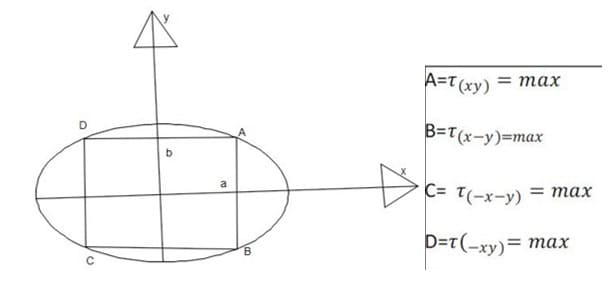
We can see that the shear stress is maximum, in four points. (The equation has more solutions)
It is obvious that fracture initiated at these points when shear stress = shear strength. For simplification we can consider the problem in 2-D. The rocks, after breakage, will behave like a cantilever beam. The overburden weight induces both direct and shear stresses in the beams. The shearing force=weight.y F=W.y

The average shear stress (Eq 9):

the average shear stress (Eq 10): is inversely proportional to the thickness h of the beam.
Therefore, for two successive layers of the same lithology (the same strength) the average shear stress τ_xy is inversely proportional to the thickness. (The load variation is negligible). The thinner the beams the greater shear stresses undergo at any plane of a certain distance from the clamped edge. The maximum shear stress will be in the clamped edges.
When this shear stress reaches the value of shear strength of the beam will break, in four or six points. So two simultaneous sets of faults were formed and they erroneously suggested that the two sets of faults in the Alps are of different phases with a time lapse more than 14Ma.
Conclusions
The high-angle faults of small dip-slip displacement have been so far ignored, by the geologists as negligible, however their additive result is very important and they should be considered. The high-angle faults cause the uplift of the rocks and form domes (mountains). The formation of domes is a pure brittle tectonic process. The geologist has no access to the depth unless there is a cross-section. In the uppermost mantle and the lowermost crust, the rocks undergo stress and so they fold once the rheological conditions are favorable. The rocks are confined, the temperature is high enough and the time is unlimited. The folds and other structures need space and they push the rocks upwards, where the rocks are no longer ductile and so they break in four or six points, if they are homogeneous and brittle. They usually appear four faces forming four fold prisms or 6fold (the tectonic units). If the rocks are not brittle, enough we have breakage in many points (even cataclastic flow) as in soft and incompetent rocks. Outcrop islets have been interpreted as intercalations despite being outlined by high-angle faults. Repetitions of some layers resulting from faulting and erosion are misinterpreted as alternations.
In the field work it is obvious that the faults in brittle rocks result in the formation of domes (mountains). The Uplift takes place by the high-angle faults in two sets and it is not a uniform movement of the rocks as a whole. Aftermath erosion results in today’s topography. The geomorphology is primarily the result of faulting and not the result of folding and erosion. The lineaments on the slopes of the mountains have been mistaken as bedding, but they are not. Uplift and Orogenesis are both brittle processes and identical.
Gigilos highland, (Crete, Greece) the Alps in Switzerland the Colorado river in USA topography are formed by vertical to sub-vertical faults. The subsequent erosion general and local has mixed up their geology. Several nappes and unconformities have been invoked which are not necessary, if the high-angle faults of small dip-slip displacement are considered. Erosion of the Colorado River area has been explained as the main factor of carving the area together with uplift. They erroneously consider that the uplift is acting as buoyancy as a whole. The faults are mistaken as extensional or rifting features but they are only uplift indicators.
Acknowledgements
I must thank several people for this work. First or all I must thank IGME Foundation who helped me to work almost all over Greece and especially in the Cyclades (in metamorphic rocks) where the structures described above, are conspicuous. Prof John Cosgrove my ex supervisor, at Imperial College (London, UK) is acknowledged for encouraging me a long time ago. My friends K. Theophillogiannakos, S. Kontalis and S. Stavrou for reminding versions of CAD, a very useful weapon for this work. My sisterin-law Yvonne Marsden-Avdis who corrected the English text. My children V. Avdis and J. Avdis for critically reading the work. Dennis Callan, the “Getty images” and Wikipedia, offering free photos for the study of Switzerland Alps and the Colorado River area, are acknowledged. My ingenious friend Christos Angelopoulos, who helped me to formulate the applied mathematics for the formation of ideal perfect prisms, is acknowledged. My friends Stavros Stavrou and Chris Cocoviadis who contributed to refine this work, are acknowledged. My friend Dem. Sofikitis, an expert in Photoshop for refining some figures. The last, but not the least, my wife Giota Belitsi, who patiently tolerated me for long time.
Figures

References
- Anderson, E.M.(1951)The dynamics of faulting and Dyke formation,Quoted in Holmes(1965) and Price(1966).
- Avdis V (1991) The effect of movement on high-angle faults on stratigraphy and structure: the Attico-Cycladic Massif, Greece. Tectonophysics 192: 293-311.
- Holmes A (1965) Principles of Physical Geology. Second Edition, London, Thomas Nelson & Sons Ltd.
- Ramsay JG (1967) Folding and Fracturing of Rocks. London Robert Maxwell M.C.
- Price N (1966) Fault and Joint Development in Brittle and Semi-Brittle Pergamon Textbook.
- Escher van der Linth (1841) quoted in Holmes 1965. 2nd Edition page 1149.
- Schmidt SM, Pfiffner OA, Froitzheim N, Schoenborn G, Kissling E (1996) Geophysical-Geological transect and tectonic evolution of the Swiss-Italian Alps. Tectonics 15.
- Stampfli M, Borel GD, Busy F, Capuzzo N, Epard JL, et al. (2001) Geology of The Western Alps, a guide book Memoires de Geologie ,(Lausanne).
- Bousquet R, Bruno- Goffé B, Roland OV, Patriat OM (2002) The tectono-metamorphic history of the Valais an domain from the Western to the Central Alps: New constraints on the evolution of the Alps. GSA Bulletin 114: 207-225.
- Avdis V (1986) Contribution to the geology of Mykonos. Geol Geophysical Research.
- Britannica encyclopedia.
- England P, Molnar (1990) Surface uplift, uplift of rocks and exhumation of rocks. Geology 18: 1173-1177.
- Faulds JE, Feuerbach DL, Miller CF, Smith EI (2001) Cenozoic Evolution of the Northern Colorado River Extensional Corridor, Southern Nevada and Northwest Arizona. Volcanism in the Lake Mead-Las Vegas Area.
- Beltrando M, Lister G, Forster MA, Dunlap WJ (2009) Dating microstructures by the 40Ar/ 39Ar step-heating technique: Deformation– pressure–temperature–time history of the Penninic Units of the Western Alps. Lithos 113.
- Jochems AP (2013) Formation, Deformation, and Incision of Colorado River terraces upstream of MOAB. Utah State University.
- Jochems AP, Pederson JL (2015) Active salt deformation and rapid, transient incision along the Colorado River near Moab, Utah. JGR Earth Surface 120: 730-744.
- Miller R (2018) Our Geological Wonderland: A trip through the Virgin River Gorge.
- Ranney W (2020) How Old Is the Grand Canyon? Geology and Earth Science News and Information.
- Ribokas B (1994-2009) The Geology of the Grand Canyon. Grand Canyon Explorer.
- Roth AA (1998) A guide to some geologically significant areas of the European Field Conference for SDA Educators.
- Schmidt S, Fuegenschuh B, Kissling E, Schuester R (2004) Tectonic map and overall architecture of the Alpine orogeny. Eclogae geol. 97.
- Strzezernski P, Guillot S, Leloup H, Ledru P, Courrioux G (2004) Brittle deformation in the Ambian and Vanoise domes in the frame of the Structural evolution of the Alpine belt. Journal of the Virtual Explorer 16: 1.
- Tataris A, Christodoulou GE (1969) Geological map 1:50000, of sheet: IGEY, Athens, Greece.
- Wood Bass W.N. (1956) Geology of the White River Uplift in Northwestern Colorado. Tulsa Geological Society Digest 24: 67-69.
© by the Authors & Gavin Publishers. This is an Open Access Journal Article Published Under Attribution-Share Alike CC BY-SA: Creative Commons Attribution-Share Alike 4.0 International License. Read More About Open Access Policy.